Sunday, October 25, 2026

USS EATON (DD510) vs USS WISCONSIN BB 64

 26 October 2026: OK. Stop this rocket ship calendar! A wise man (might have been some ancient world philosopher) said "the days are long but the years are short!" Sounds right to me! Only a relative few days left in 2026! Damn! 

Back in the day, your scribe was stationed aboard the U.S. destroyer USS Cony (DD 508) homeported in Norfolk VA. We were in Destroyer Squadron 28 and spent most of 1967 in the South China Sea supporting U.S. land forces with shore bombardment (among other things). USS Eaton DD510 was our squadron mate and for obvious reasons we all referred to her as the "Fighting Five And Dime." Here's a story of part of her life prior to that from the web site 1945.

                                        ~~~~~~~~~~~~~


On May 6, 1956, off the Virginia Capes, the destroyer USS Eaton, radar dead for four days, turned hard at 27 knots toward a man-overboard call that turned out to be a floating white hat, straight into the path of the 57,500-ton battleship USS Wisconsin.

On Sunday, May 6, 1956, the Fletcher-class Destroyer Escort USS Eaton (DDE-510) sailed in heavy fog with a small task force. At the center of the task force was the aircraft carrier USS Coral Sea (CVA-134), accompanied by the battleship Wisconsin (BB-63), the heavy cruiser Des Moines (CA-134), and three more destroyer escorts of Destroyer Division 22. The Eaton served as the division’s flagship, with the Commodore aboard. Cruising off the Virginia Capes in the fog, the task force was not looking for the Soviet Navy that day. It was just out for the weekend to entertain politicians with a demonstration of the Navy’s power and capabilities at sea. That morning’s fog reduced visibility so much that the politicians aboard saw little of the other ships in the formation.


 Destroyer Photo Index DD-510 / DDE-510 USS EATON

Aboard the Eaton, the fog was especially troublesome. Her radar had been out of service for the last 4 days. She navigated within the formation, keeping her position by watching the other ships fade in and out of the fog.

They could catch glimpses of the Coral Sea 5,400 yards to their right, but somewhere out there in the fog were a battleship and a heavy cruiser they couldn’t see, and without radar to mark their locations, that was cause for worry.  As long as they held their position off the Coral Sea, they should be all right.

At 3:10 PM, as sailors aboard the Eaton were preparing for a live-fire demonstration of their 5” guns, a report reached the bridge that a lookout on the Coral Sea had seen a sailor in the water.

The little destroyer escort’s position may not have been ideal for recovering the lost sailor, but the Commodore aboard was in charge of the escorts. He ordered the Eaton to make a hard turn to starboard and increase speed to 27 knots. The crew, already at battle stations for the gunnery exercise, prepared a boat to be lowered as all available hands scanned the waters for the missing man.

The Eaton was picking up speed rapidly, the fog rolling by like low clouds. To the right, the fog suddenly darkened to reveal a nightmare: the towering bow of the 57,500-ton battleship Wisconsin emerged from the mist and bore down on the tiny destroyer.

The Wisconsin was the last of four Iowa-class battleships to be built. The Navy planned to build six of these battleships, but by the end of WWII, it had completed only four. Experienced workers built Wisconsin, believed to be the best of the four in build quality, and launched it on December 7, 1943. Wisconsin holds the distinction of being the last battleship the United States ever built. 
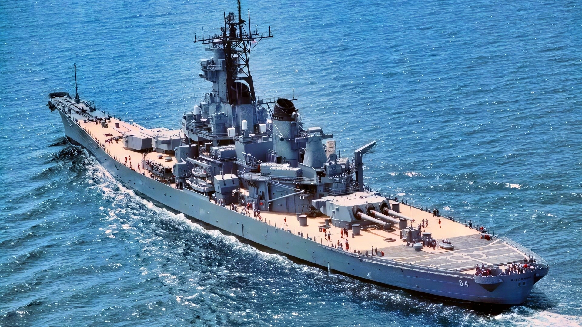
USS Wisconsin Battleship US Navy Photo Creative Commons
USS Wisconsin

The Iowa class was also incredibly fast for a battleship. In 1968, battleship New Jersey established the world speed record for a battleship at 35.2 knots during sea trials. 

Incredibly, New Jersey set this record with 22-year-old steam turbines. Wisconsin could easily make 33 knots at flank speed. The secret to this speed was a long, tapered bow that sliced through the water like a knife, cleaving away the ocean along the 887-foot length of her hull.  The bow section was purposely unarmored, as nothing vital to the ship’s survival in battle lay that far forward. Other battleships at flank speed tended to “bury their nose” in the ocean, limiting their speed, but the long, light bow of Wisconsin and other Iowa-class battleships added lift at speed.

The Wisconsin struck the right side of the Eaton at the forward 5” inch gun mount at a speed of 17 mph, destroying it. Below deck, the bow punched through the Chief’s Mess, the crew’s galley, the forward fireroom, and severed her keel, the backbone that holds a ship together. The impact severed steam release pipes in the mast, sounding like rapid gunfire as white clouds sputtered and billowed out.

 This May 8, 1956 photograph shows USS Eaton after its collision with USS Wisconsin in Chesapeake Bay. The destroyer suffered heavy structural damage to its side and superstructure but remained afloat

Miraculously, only two people were injured. Her interior compartments were mostly empty, and the crew on deck looked for a man in the water who wasn’t there. A lookout on the Coral Sea spotted a Navy white hat in the fog, triggering a false alarm. Eaton would survive just barely. With her keel broken, the ship’s bow flopped up and down with the swells. Damage control parties rigged her anchor chains as suspended braces to keep the ship together as the Eaton staggered back to port.

Damage to Wisconsin’s light bow structure was considerable after hitting a 2,000-ton object at 17 mph. The front of her bow twisted to the right like a boxer’s nose broken in a prize fight, and she took a nasty 68-foot cut in her hull that ended at the heavier framing aft.

The light construction of Wisconsin’s bow might have saved the Eaton from being cut in half like a hoagie sandwich in a deli.

The bow steel was only about 1.5 inches thick, and the first 80 feet of the bow acted like a “Crumple zone” in a modern car, deforming and absorbing impact forces. Aside from a mangled bow, the Wisconsin was undamaged and not in danger of sinking.

 On May 6, 1956, the United States Navy destroyer USS Eaton (DDE-510) suffered serious damage after colliding with the large battleship USS Wisconsin (BB-64) during training operations in the Atlantic

So, what do you do with a battleship missing 70 feet of bow?

In 1956, plenty of parts were on hand for Fletcher-class destroyers like the USS Eaton; the Navy had built 175 of them during WWII, and many experienced shipyard workers still knew how to work on them. Wisconsin presented a few more problems.  Of the six Iowa’s originally planned, only four were built, and Wisconsin was the last, completed in 1943.

After WWII, the unfinished battleships Illinois and Kentucky slowly rusted away in shipyards.

The Illinois was only 22% complete and was mostly an empty shell.

The Kentucky was 77% complete, and the Navy occasionally took pieces from her to repair the four Iowa-class battleships still in service. Kentucky did have a complete bow section, however, and the Navy decided to cut it free and fit it to Wisconsin. This was easier because the bow of Iowa-class battleships was welded, not riveted.

Workers cut away a 68-foot, 150-ton section of Kentucky’s bow and barged it from Hampton Roads to the Norfolk Naval Shipyard, where Wisconsin waited. In today’s world, where repairs to Navy ships can take years, something miraculous happened.

They replaced Wisconsin’s bow in just 16 days.

Along with her new bow, USS Wisconsin got a new callsign.

Her crew previously called her “The Big Wisky”; now, with a new bow from the Kentucky, she became “WisKY” in memory of her unfinished sister ship. 

Wisconsin returned to duty, taking a piece of the Kentucky with her on every cruise, and remained in service off and on until she was finally decommissioned in 1991, when she returned to Norfolk as a museum ship.

                                         ~~~~~~~~~~~

We had an expression in those days (probably still appropriate today) the said "a collision at sea can spoil your whole day!" In fact there was a nicely inscribed sign to that effect on the bridge of two on the ships I served on. Apparently there were no punishments mentioned in this case. 

PS: MM is closing in on the one million reader mark - we're at 868,000 as of this week!  

Until next time, stay safe!

                                    Fair winds.

                                 Old Salt 

Sunday, October 11, 2026

STORM EXPOSES WRECK

 11 October 2026: 

Nasty weather, after a pleasant week and a big Nor'easter the previous week, is back as the remnants of Hurricane Isaias [Ed: fortunately this is written as no one can pronounce that name!] runs to the northeast bringing rain and some (not strong) winds. But in the spirit of the weather, we bring you a piece from FOX WEATHER about a shipwreck on Nantucket uncovered during the recent nor'easter.

                                     ~~~~~~~~~~~~~~~~

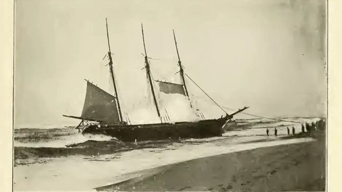
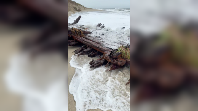
NANTUCKET, Mass. - As a powerful nor’easter lashed the East Coast, relentless wind, rain and waves triggered colossal coastal erosion on Nantucket, unearthing a piece of the island’s maritime history.

The Warren Sawyer wrecked off Nantucket around 11 p.m. on Dec. 22, 1884, while carrying a cargo of cotton and scrap iron.

A large section of a shipwreck was spotted Saturday along Nantucket’s south shore on the beach near Point of Breakers and the Sewer Beds, where relentless waves caused significant coastal erosion.


The wooden wreckage is believed to be part of the 19th-century schooner Warren Sawyer, which ran aground near Miacomet Beach on Dec. 22, 1884, the Nantucket Current reported.

The doomed ship was traveling to Boston from New Orleans, hauling a cargo of cotton and scarp iron when it was blown off course by gale-force winds.

A newspaper account chronicled the 1884 shipwreck and the heroic efforts that saved every member of the crew.

According to an account published in The Inquirer and Mirror in 1945, Patrolman Eugene Clisby spotted the schooner’s lights near Miacomet Rip and rushed to the Surfside lifesaving station to call all hands.

The Warren Sawyer wrecked off Nantucket around 11 p.m. on Dec. 22, 1884, while carrying a cargo of cotton and scrap iron.

The surf was raging, surrounding the schooner and leaving only its masts visible in the darkness. Capt. Veeder fired a line toward the vessel’s jibstay, but the crew was too weakened by the cold to move forward and secure it.

During a brief lull in the waves, Patrolman Williams ran down the beach and used a hand line to send another line over the schooner’s bow. The sailors crossed the sea-washed deck and secured it, allowing the lifesaving crew to attach a hawser and rig a breech buoy.

The rescue was made more difficult by the schooner’s violent movement in the surf, but the experienced lifesavers worked through the night.

By the morning of Dec. 23, every member of the Warren Sawyer’s crew had been safely brought ashore, the newspaper article recounted.

This isn’t the first time Nantucket’s historic shipwreck has made an appearance on the South Shore beach.

The storm uncovered a section of the Warren Sawyer in the same area where pieces of the schooner resurfaced in December 2022.

More than a century after the schooner wrecked, the nor’easter’s powerful waves have once again surfaced the remnants of the lost vessel from beneath the Nantucket sand.

                                                  ~~~~~~~~~~

Sometimes nasty storms can offer us surprising discoveries. And there is a lot of history along our shores - and those of other countries - just waiting for Mother Nature to show us a glimpse of what is waiting. 

And by the way, Maritime Maunder has now reached just short of 720,000 readers. Will we hit one million? Who knows, but wow! Amazing!

Until next time, stay safe!

                                 Fair Winds, 

                                   Old Salt 


Sunday, September 27, 2026

NOAH'S ARK?

 27 September 2026: We are finishing up the tail end (we hope) of a particularly nasty Nor'easter here on the American east coast. Major flooding, high winds, huge surf, and all of the associated fun stuff that goes along with it. Many folks are saying worst since super storm Sandy. Not sure that's accurate, but it will give you an idea of the joy we just experienced! Things are returning slowly to normal and waiting for the waters to recede enough so I can get to the waterfront marina and check my boat! 

We have an interesting bit today from the British Daily Mail.

                                         ~~~~~~~~~~~~~~~


Noah's Ark mystery deepens as new scans show boat-shaped formation is more than just rock

A mysterious boat-shaped geological formation in the mountains of eastern Turkey has long been dismissed as nothing more than a solid mass of natural rock.

But an international team investigating the Durupınar Formation near Mount Ararat believes it could contain the remains of Noah’s Ark.

According to the Bible, the massive vessel saved Noah, his family and every kind of animal from annihilation during a catastrophic flood that some biblical chronologies place more than 4,300 years ago.

Now, a new radar survey has detected strong subsurface anomalies and distinct layers inside the 515-foot-long formation, challenging the idea that it is one homogeneous block of rock.

 A new radar survey has detected strong subsurface anomalies and distinct layers inside the 515-foot-long formation, challenging the idea that it is one homogeneous block of rock


Led by Dr Khosrow Bakhtar, the survey used BakhtarRadar, a specialized imaging system developed through US Air Force research, to probe deeper beneath the site than earlier scans.

Noah’s Ark Scans founder Andrew Jones, who is part of the research team, said the deeper readings processed so far had yet to reveal a clear boundary between the formation and the underlying bedrock.

The team is still analyzing the data and will use the results to select locations for core drilling that could establish what lies beneath the formation.

‘We believe the Durupınar Formation is the remains of Noah’s Ark, and that is exactly why we want to put it through the strongest scientific testing we can,’ Jones said.

However, the researchers acknowledged that the results are preliminary and that radar anomalies alone do not prove the formation has an archaeological origin.

Bakhtar shared: 'My team and I are carefully evaluating the collected subsurface data, which aids in planning the core drilling pattern to be performed at the site. 

'We will use BakhtarRadar's unique capability to directly distinguish any still preserved petrified, man-worked timbers from the natural host formation and its varying mineralogy.'

The team expects to release a preliminary technical report in the coming weeks identifying the strongest anomalies, providing a clearer view of the underlying geology and determining the best locations for targeted core drilling. 

The samples would allow researchers to test the radar findings against physical evidence from inside the formation. 

Located just 18 miles south of Mount Ararat, Turkey's highest peak, the Durupinar Formation has only been known to the modern world for less than a century.

According to local reports, heavy rains and earthquakes in May 1948 washed away the surrounding mud, revealing the mysterious formation. It was then discovered by a Kurdish shepherd.

The Bible states that Noah's Ark came to rest on the 'mountains of Ararat' after a 150-day flood that drowned the Earth and every living creature not sheltered inside the wooden vessel.

What is intriguing is that the formation sits near a mountain with a peak that some believe matches the ark's shape and dimensions. 

 Researchers have started drilling at Turkey's Durupinar formation, using a custom robot to search for the remains of the biblical Noah's Ark.

According to biblical measurements, the ark was '300 cubits long, 50 cubits wide, and 30 cubits high,' roughly 515 feet long, 86 feet wide and 52 feet tall.

The idea that the ark landed on Mount Ararat has long sparked debate.

While many scientists argue that the formation is a naturally occurring geological feature, others are convinced it points to something far more extraordinary.

The team at Noah's Ark Scans firmly believes the latter.

Jones has been investigating the site since 2016, using ground-penetrating radar to see deeper underground, finding what he believes is a network of 'corridors' converging on a hollow central chamber he dubbed the atrium.

He linked the discovery to the Bible's description of the Ark, which states the boat contained three internal levels built to shelter Noah, his family and pairs of animals.

'God told Noah to bring the animals in. And so these animals would have stayed there, plus Noah and his family,' Jones told GB News.

'What's interesting is that these voids are lining up below the ground - and they're not just random. These tunnels also follow a pattern. GPR is just a way to look below the soil using radar.'

He added that further studies using infrared thermography (IRT), a heat-sensing technology that can uncover hidden structures underground, have also suggested the presence of a ship-shaped hull buried deep in the soil.

Jones told GB News that he and his team collected 88 samples from inside and outside of the ship in 2024.

Soil testing in the area showed extremely high levels of potassium, consistent with massive amounts of decomposed lumber.

'However, due to the extremely cold climate, many parts of the Ark are still intact and petrified. It spends almost six months out of the year completely frozen,' Noah's Ark Scans explained in an X post.

In 2024, Jones revealed that he and his team uncovered angular structures as deep as 20 feet bn Genesis 6:14, the Bible describes the ark: 'Make thee an ark of gopher wood; rooms shalt thou make in the ark, and shalt pitch it within and without with pitch.'

'This is not what you'd expect to see if the site were simply a solid block of rock or the result of random mudflow debris,' Jones told The Christian Broadcasting Network.

'But it is exactly what you'd expect to find if this were a man-made boat, consistent with the biblical specifications of Noah's Ark.'

The team has also performed soil testing, uncovering what Jones described as 'some interesting things.'

'We noticed that the grass growing within the boat-shaped formation is a different color compared to the area just outside it,' Jones said, suggesting this could point to a man-made origin rather than a natural one.

William Crabtree, another member of Noah's Ark Scans, added that a tunnel appears to run from the tip of the formation toward the middle, and it is large enough to walk through.

'The ultimate goal is not just soil test, which is great, or GPR scans, but to get inside the ship somehow,' Jones told Patterns of Evidence.

'Core drilling, getting samples deep inside of it to where we see the substructure, these voids, put a camera in it. This is an opportunity coming up that possibly will allow us to do that next season.

 Researchers drill into the Durupinar formation, a boat-shaped formation in the mountains of eastern Turkey, on Tuesday.

'Whatever happens, whenever God opens doors, we will continue working on the site.'

                                                  ~~~~~~~~~~~~~~~~~~~~~~~~~~~~~

Well, what do you think? Is it the Ark or just some random rock formation. I would like to believe it is old man Noah's yacht, but I guess time will tell. Surely they're spending some serious money on their hunch!

Until next time, stay safe friends. 

                      Fair Winds,

                            Old Salt